{I have updated this post and corrected errors as best I could. New post can be found here: http://jjwtrains.blogspot.com/2012/09/a-good-place-to-model-redone.html
A person from the area has brought to my attention a few minor errors in this post. Errors are corrected by red lettering. While visiting Minnesota, I came across the small town of Villard, MN. It has a station, and a large grain complex that was served by the railroad,
Soo Line Burlington Northern to be exact. Anyway, here is a listing of buildings that were served by the railroad in town:
- Station depot/ both passenger and freight.
- Grain elevator/ loading and unloading spots, plus a car spot by the main office.
- Grain storage building 1/ 3 car spots
- Grain storage building 2/ 4-5 car spots
And here are some photos to give you a general idea of what the town looks like:
 |
| Here is the front of the Depot, with both the freight and the passenger areas, I am standing on a trail next to the 100 remaining fee of track still in town. |
 |
| In the fore ground, you can see the track. The track would probably have continued to the left of the metal grain silos. A spur track would have gone between the silos and the elevator. |
The trail could possibly be on a second set of tracks, making a runaround. From photos, I now know that the station was actually between the runaround tracks. Therefore, a second set of tracks would have gone behind the depot, and past the elevator. The tracks continue in the distance to go between Lake Amelia and Lake Villard on a man-made land bridge.
Here is the old feed building, or what's left of it. This would have been a truck transfer point, as there are doors on either side (one side for trains, the other for trucks).
The elevator was still running in the 60s, although the tracks may have been ripped up. I say that because there is a scale in place for trucks, and a 1960s-70s truck is in the weeds bearing the name of the Elevator Co-op.
Prior to this Co-op, the elevator was owned by Great Western Elevator Co.
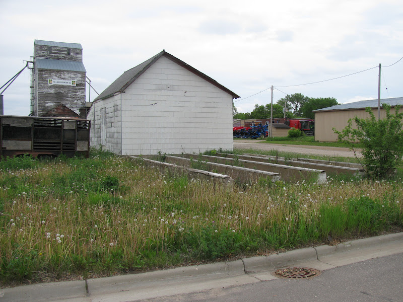
here is the second grain storage building. If this were supplied by rail and truck, it is likely that the trains had a platform leading to the building as the doors on the other side are too low.
Here is the overall complex
And there is where the trains would go to load/unload cars.
 |
| Finally, here is what I think Villard, MN looked like. Pretty much a generic small town elevator yard. Maroon: station, red: feed storage, green: elevator, gray: grain silos, dark gray: a utility building on a spur. After looking at photos, the runaround went around either side of the depot. There was no spur leading to utility buildings, and there was no spur going to the elevator, the elevator was serviced on the same track as the runaround which went behind the depot. A new plan will follow shortly. |


 Here is the old feed building, or what's left of it. This would have been a truck transfer point, as there are doors on either side (one side for trains, the other for trucks).
 The elevator was still running in the 60s, although the tracks may have been ripped up. I say that because there is a scale in place for trucks, and a 1960s-70s truck is in the weeds bearing the name of the Elevator Co-op.

 Prior to this Co-op, the elevator was owned by Great Western Elevator Co.
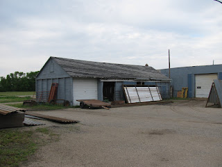 here is the second grain storage building. If this were supplied by rail and truck, it is likely that the trains had a platform leading to the building as the doors on the other side are too low.
 Here is the overall complex


Oh my goodness! I grew up in Villard and my very first "real" job was painting that depot. I always thought it would be a great modeling project, too. The map you drew is not correct, but it's relatively close.
ReplyDeleteBTW, it was not the Soo Line. Originally, it was call the Little Falls and Dakota RR (began in Little Falls and ran to the Dakota Border--not sure where--Brown's Valley maybe.) It ended up Northern Pacific (Villard is named for Henry Villard) and ended life as BN.
BN sold the depot in 1974. The line was abandoned and finally torn up in 1982. It's now a recreation trail.
If you're interested, I may be able to supply historical pictures and information on the layout.
Thanks for the memories.
Thank you for the corrections, I'll get to work on that in due time. Obviously, its hard to get a track plan made accurately when most of the track has disappeared. I will add the historical information that you have provided in the comment.
DeleteAnd I would also love to have any historical images you might have. in a way, this town is somewhat of a mystery for me that began back when I first moved to nearby Glenwood 15 years ago. Finally, the case might be closed for what this little town looked like when the railroad kept it afloat.
Finally, The BN explains why Glenwood was a junction town. Soo Line ran North-South through Glenwood. So that means that BN ran East-West. You can reply with a comment here, as it shows up in my inbox.
Thank you!
Comments and clarifications: For most of its life, the depot was Northern Pacific. That would be from 1882 until BN bought out NP. (Sorry don't know the date: 1960-70 period.)
ReplyDeleteRegarding the pictures:
The depot dates to 1882. It was and may still be listed on National Registry of Historic Buildings.
The next picture from the depot east toward the elevator (built 1902) is spot on: the main line ran on one side of those metal bins and the spur ran between the bins and the elevator. Old pictures show a water tower that stood roughly where the recreation trail and street meet. It may have been too far away for the main line and served a turnout.
The next picture from the front of the depot toward the Villard sign and trees: there was an outdoor privy near the tracks and an old switch which I believe may have served an old line to the old water tower. The turnout for the line that served the elevator would have been way back beyond the trees. BTW, the man-made land bridge is not man-made; it is natural as shown on maps predating the railroad including the original county survey.
The picture from behind the depot showing the motorhome: The tracks ran between the depot and motorhome. Where the motorhome sits, but slightly farther back, was an unloading ramp or station.
The next picture shows some concrete runners and a feed building. The trick to understanding a lot of what was has to do with so many destructive fires for businesses. This is the sight of the original grain elevator in Villard, destroyed by fire in the 1920's I think. At it's peak, Villard had three grain elevators.
In the next picture up the street toward the grain elevator: I believe there was spur running down the right hand side of the picture/street. Behind the building on the right was an old unloading platform. Across the street from the standing elevator was the largest elevator in Villard which would have needed a spur for service. It burned down in the early 30's I believe and was not rebuilt.
The truck scale/weigh station was not there when I left the area in the late 70's. My guess is this: when it was obvious the rail was going to be abandoned, the Villard Elevator and Implement (not a co-op btw) built a terminal on the Soo Line over by Glenwood and trucked the grain to rail. I'm guessing that because they were using weight-restricted roads, they installed the scale for weighing the trucks before they left.
In the next picture, the biggest elevator stood roughly where the tractors are: there was evidence of old switching to the east.
In the final picture: "the second grain storage" was, it is my understanding, part of the old coal company from when houses were heated by coal. When coal went away, the buildings were repurposed. The prior coal company buildings burned; I believe but am not sure that they stood down behind that new (circa 1980s)truck scale.
To the east of the coal company was once a livestock yard; Villard was also a livestock shipping point. There were evidences of old switches in the area.